The themes of climate, sustainability and greening are a high priority on the agendas of municipalities. Ultimately, these aspects are all highly relevant for the design and usability of the physical living environment. Many municipalities have very specific ambitions regarding these themes. It is becoming increasingly necessary to address these considerations: the changing climate is becoming very noticeable in the city, with examples such as sewers flooding during peak rainfall events and experiences of heat stress in very warm and dry periods. The Deltaplan “Ruimtelijke Adaptatie” identifies the climate themes (such as flooding, heat stress, drought and (consequences of) flooding, whereby measures need to be taken.
In order to provide insightful information and to quantify climate indicators related to these themes, AeroVision has developed the Urban Climate Index (UCI). Analysis, indexing, and change detection of the climate indicators in the urban living environment are central aspects of the UCI. The UCI provides a uniform method to gain insight into the risks and subsequent measures, and to compare these aspects. For example, a good indication of the amount, location, and health of vegetation can provide better insights into the effects of this vegetation on: Greening (m2/m2), trees, wadi's, ...), buffering rainwater, cooling of the environment, and health and wellbeing. A good understanding of the number of solar panels provides better insight into where energy is generated by individuals, companies, and governments so that energy neutral neighbourhoods, for example, can be managed more effectively.
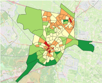
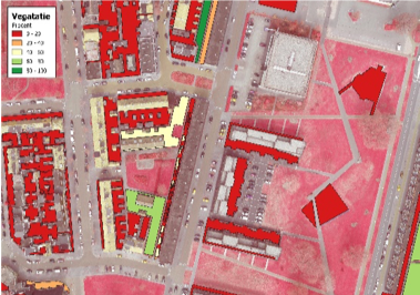
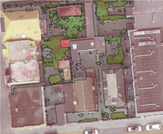
Figures: Left: Green index for Amersfoort municipality, split into neighbourhoods; Centre: Green index of private spaces on street/neighbourhood level; Right: Location ‘green’ at address level.
The added value of UCI is that it provides accurate and current insights. With the help of Remote Sensing images, the situations and trends become clear on a neighbourhood, street, and address level. Providing only data does not work – we know this from experience. More useful is how this data can be translated into useful information that can be used directly for decision making on complex issues and the eventual management of implementing the relevant measures. The UCI links the required usable data and provides a quantitative insight into the otherwise complex nature of urban climate themes.
What is the role of AeroVision in this project?
AeroVision is an advice and project management company focused on the realisation of ideas for obtaining and making optimum use of (geo) information. AeroVision offers research and advice services throughout the project based on 5 aspects:
- In the first step of the research and advice service, we will help the organisation to uncover the necessary information that is related to climate issues;
- Insight into the added value of imagery (satellites, aerial photos, drones) to obtain policy-relevant information for the relevant climate issues (greenery, water, paving etc.);
- A method of monitoring the climate topic and the changes in recent years per neighbourhood;
- Creation of the desired index (%/m2 etc.) per desired level (address, street, neighbourhood, city, municipality, region);
- Advice on the use of data and information for decision making and implementation.